Parade Streetscape Upgrade | WMS Engineering
The Parade, Norwood SA, Australia

Parade Streetscape Upgrade

Flood impact assessment to support the Parade Masterplan
Ashley
Questions? Get in touch today.
Ashley Chen

Client

Dryside Engineering

Scope

Flood modeling to assess existing conditions and proposed streetscape design impacts for The Parade

Impact

Enhanced flood resilience with improved drainage design and mitigated flood risk, ensuring safer streetscapes and informed urban planning for The Parade Masterplan's successful implementation
Parade Streetscape Aerial

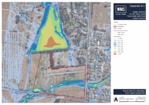
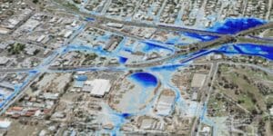
The Parade Streetscape Upgrade aimed to enhance the functionality, flood resilience, and visual amenity of a 1.6 km section of The Parade. As part of this effort, WMS was engaged to perform flood modeling services to support DSE’s detailed design by assessing existing flood conditions and evaluating the impact of proposed design changes. The primary focus was on understanding overland flow behavior and ensured the upgraded stormwater system effectively handled rainfall runoff.

WMS enhanced previous hydraulic models with updates aligning with Australian Rainfall and Runoff 2019 guidelines. Improvements included topographical data refinements, sub-grid sampling, and quadtree mesh applications for more precise flow path representation and flood depth analysis. These refinements allowed for a more accurate assessment of minor overland flow paths and their interaction with the proposed streetscape features.

The flood modeling results confirmed consistency with previous assessments, while minor differences in flow depths and extents are primarily due to improved topographical accuracy. The analysis ensured that the streetscape design did not affect flood behavior and supported a safer, more functional urban environment for the NPSP Council’s Parade Masterplan.

Related Projects

Alluvium for Wellington Shire Council

Maffra Drainage and Integrated Water Management Strategy

Site Inspection of Farm Levee at North Star
SMK Consultants

Water Modelling Solutions and SMK Consultants

WMS and SMK Consultants Collaborate to have levees approved for farmers across rural New South Wales.
Toowoomba Regional Council

Bostock Road Bridge Design

Toowoomba Regional Council

Maclagan and Quinalow Floodplain Risk Management Study and Plan

Glenelg Hopkins Catchment Management Authority

Port Fairy Hydraulic Model Review

Gatton flood map
Toowoomba Regional Council

Stormwater Catchment Modelling, Planning and Design for Gatton

WMS, in conjunction with RMA Engineers, were commissioned to undertake stormwater catchment modelling, planning and design for the township of Gatton.
Sunshine Coast Storm Surge
Sunshine Coast Regional Council (SCRC)

Sunshine Coast Extreme Flood Hazard Mapping

Filling a Knowledge Gap on Flood Severity in Rare Events