Glengarry Stormwater Study | WMS Engineering
Cairnbrook Rd, Glengarry VIC, Australia

Glengarry Stormwater Study

Comprehensive flood mitigation study for the township of Glengarry
Ashley
Questions? Get in touch today.
Ashley Chen

Client

Latrobe City Council

Scope

Flood study with modelling, analysis, mitigation findings, and recommendations for LCC

Impact

Effective solutions to reduce flood risks in Glengarry, ensuring community safety and minimising property damage during major flood events

WMS was engaged by Latrobe City Council (LCC) to conduct a comprehensive flood mitigation study for the township of Glengarry. This project aimed to review and enhance previous hydraulic models, particularly focusing on the waterways Eaglehawk Creek and Four Mile Creek in alignment with the updated Australian Rainfall and Runoff Guidelines (ARR19). The study involved hydraulic modelling using TUFLOW software for flood behaviour assessment during a 1% Annual Exceedance Probability event.

Glengarry Mapped

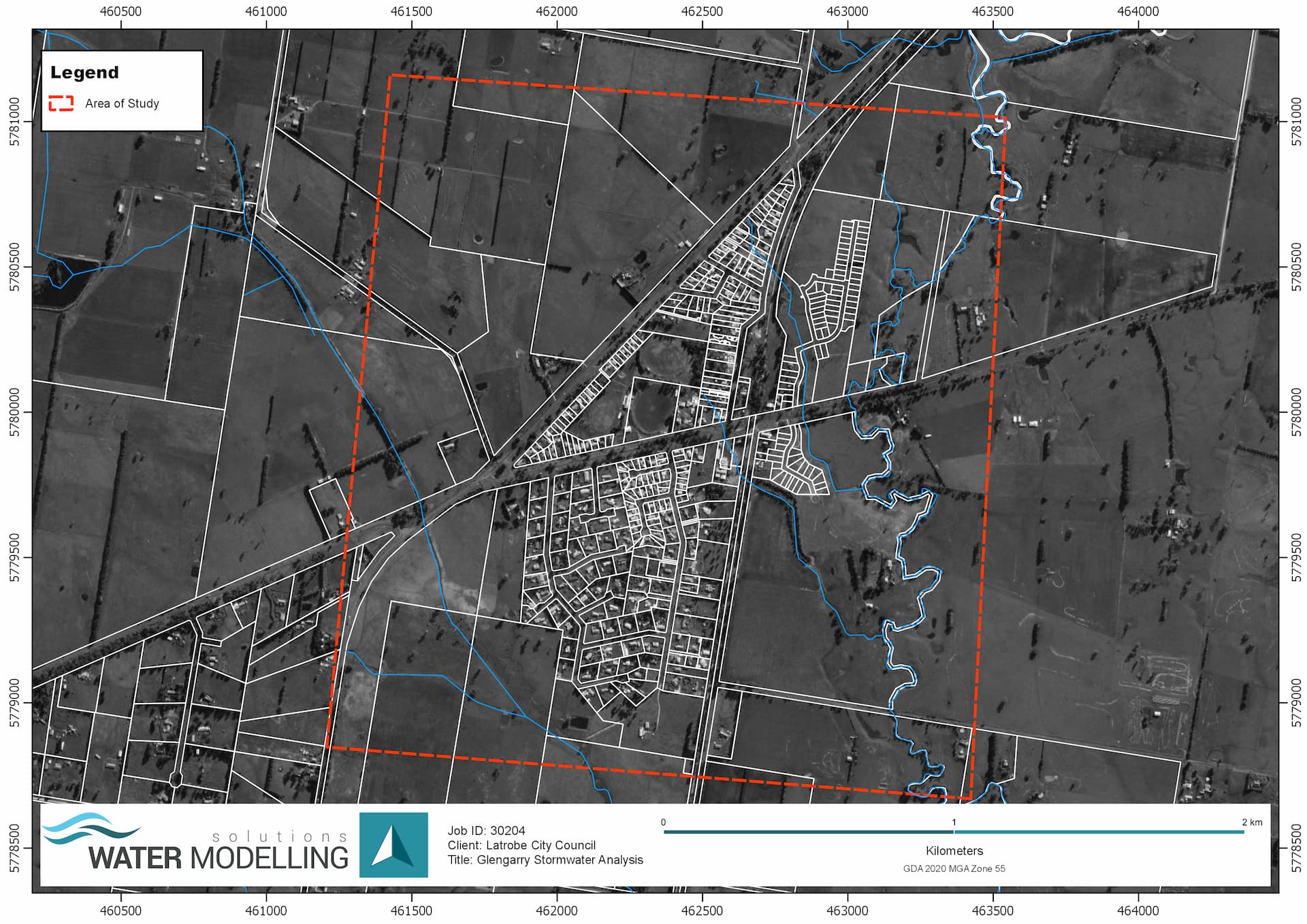
The project assessed four mitigation options collaboratively developed with LCC and the West Gippsland Catchment Management Authority (WGCMA). Results indicated that the Traralgon Maffra Road Levee Mitigation Option was the most effective, significantly reducing flood risk with minimal adverse off-site impacts.

Glengarry Site Visit

WMS recommended further steps, including a comprehensive cost-benefit analysis of the detailed mitigation options. These proactive measures guided Council in prioritising flood risk reduction strategies, ensuring community resilience and long-term sustainability for the Glengarry township.

Related Projects

Queensland Rail

Duck Creek Flood Study

Cowra Water Treatment Plant
Cowra Shire Council

Cowra Water Treatment Plant Reservoir CFD Modelling

CFD modelling to determine chlorine contact time
Arup

Roseneath Unsealed Roads Hydraulic Assessment

VIC Department of Environment, Land, Water and Planning (DELWP)

Lower Barwon River and Lower Moorabool River Flood Risk Management Study Review

Yarranlea Solar Farm
icubed consulting

Yarranlea Solar Farm Flood Impact Assessment

A Smooth Path to DA Approval
Site Inspection of Farm Levee at North Star
SMK Consultants

Water Modelling Solutions and SMK Consultants

WMS and SMK Consultants Collaborate to have levees approved for farmers across rural New South Wales.
Local Government map
Toowoomba Regional Council

Whole of LGA Flood Mapping

A Rapid, Low Cost Alternative to Detailed Flood Studies