Sunshine LGA Road Immunity Analysis | WMS Engineering Opens in a new tab
Sunshine Coast QLD, Australia

Sunshine LGA Road Immunity Analysis

Semi-automated Tool Development
Monika Balicki
Questions? Get in touch today.
Monika Balicki

Client

Sunshine Coast Council

Scope

Development of a semi-automated tool to assess road immunity

Impact

Development of a workflow and datasets which can be used to inform transport planning and disaster management and operations
Monika Balicki
Questions? Get in touch today.
Monika Balicki

Client

Sunshine Coast Council

Scope

Development of a semi-automated tool to assess road immunity

Impact

Development of a workflow and datasets which can be used to inform transport planning and disaster management and operations

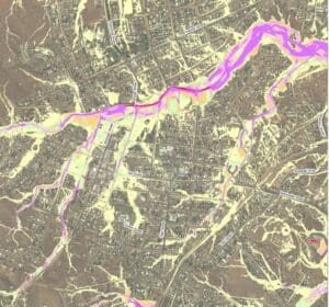
Sunshine Coast Council has comprehensive flood study results covering the majority of its Local Government Area (LGA). This project used these existing flood study results to automatically determine the immunity of every public road in the LGA.

The process made use of Council’s road centreline GIS dataset, in conjunction with up-to-date ALS elevation and land use classification data. The data was analysed using a combination of GIS tools and python scripting. Flood levels were interpolated to find the indicative ‘overtopping’ Annual Exceedance Probability along each road segment.

The process was largely automated and the developed methodology is flexible enough such that the tool can be easily rerun in the future as input data is updated.

Mapping and GIS files were produced showing road flood immunity for every public road in the LGA. This data can be used by various departments within Council in conjunction with other datasets to inform transport planning and disaster management and operations.

Want to discuss a similar project? Get a quote today.

Get a Quote
Related Projects
TC Alfred coastal erosion
NSW Crown Lands

Flood Impact Assessment of Crown Lands Assets

Condition Assessments and Recommendations for Remediation Actions
Jallara Park Drawing
Cairns Regional Council

Jalarra Park Detention Basin

WMS teamed up with civil engineering firm Dryside Engineering to deliver the FIA and detailed design of the basin.
Marshall Precinct
City of Greater Geelong

Marshall Precinct Stormwater Management Strategy

The primary aim of the SWMS is to investigate the impact that the transition from rural residential land uses into predominantly urban, residential development will have on surface water within and beyond the PSP boundary.
buchan caves 1
Parks Victoria

Buchan Caves Reserve – Flood Modelling

Hydraulic assessment to inform post-disaster restoration
Hay Street Pedestrian Bridge
Brisbane City Council

Hay Street Pedestrian Bridge Replacement

The objective of this project was to undertake hydraulic modelling and flood impact assessment to inform the design of the new bridge.
Daly St Site Visit 1
Clare & Gilbert Valleys Council

Daly St Drainage Detailed Design 

Stormwater impact assessment
Local Government map
Toowoomba Regional Council

Whole of LGA Flood Mapping

A Rapid, Low Cost Alternative to Detailed Flood Studies